Ground investigation data, processed in minutes, not hours.
Drop in the AGS file, the logs, the Schedule 2 and the lab results. StrataScope checks them, draws the plan, the logs, the sections and the graphs, and builds the factual report — so engineers spend their time on interpretation, not formatting.
Accounts are set up for you. Request an account or demo at info@mte-hq.co.uk.
Data intakeBorehole registerSite planConsolidated logsFencesGraphsTesting scheduleIssue
LHR · R26023Demo contract — invented data
First pass, plainly stated.
Everything StrataScope draws or writes is a first-pass suggestion for a competent engineer to verify. It is never a design value.
Reads AGS 4
Reads AGS 3 and 3.1
Reads logs as PDF, scan or photo
Reads Schedule 2 and lab results
Writes Word factual report
Writes Excel test graphs
Keeps BS 5930 descriptions as logged
Reports to AGS Guide to GI Reports
Reads AGS 4
Reads AGS 3 and 3.1
Reads logs as PDF, scan or photo
Reads Schedule 2 and lab results
Writes Word factual report
Writes Excel test graphs
Keeps BS 5930 descriptions as logged
Reports to AGS Guide to GI Reports
Features
Everything between the rig and the report.
One checked dataset drives every output. The register, the plan, the logs, the sections and the report all read the same holes.
Checks that catch it before the client does
Every AGS file is checked against the AGS rules, with a conformance report you can open from the register. A file that needs altering — a dropped digit in a coordinate, holes in two grids, overlapping strata — imports nothing until you have seen each change, before and after, and chosen.
BH-03 · SAMP 4.50no test scheduled
BH-07 · ISPT 12.00below hole depth
40 holespassed
Logs, read and consolidated
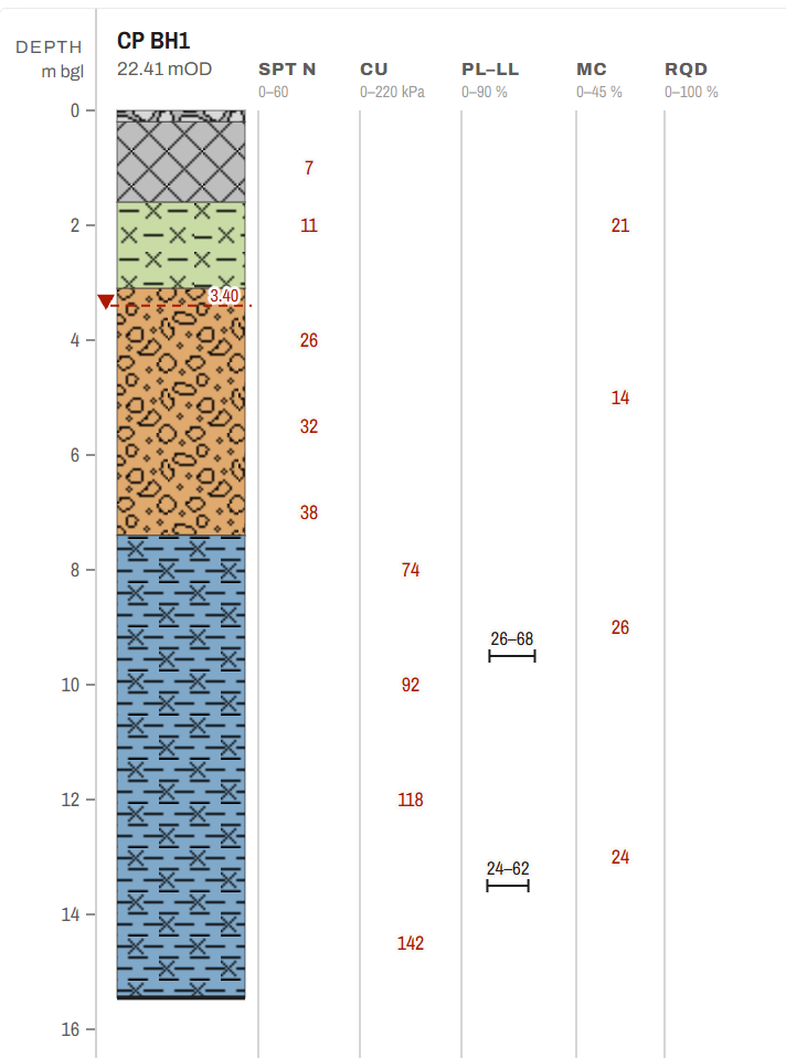
Strata coloured by named unit and hatched with the BGS ornaments, with SPT N, cu, moisture content and RQD printed as the value at the test depth. A log that only exists as a PDF, scan or photo is read, and every value read is recorded as read: the factual report says hole by hole which values came from the logs, and the AGS export states each record's source.
Site plans and sections, drawn for you
Every hole on the plan, drawn by how it was excavated. Draw a line between holes and read the section; north–south and east–west sections through every hole are drawn to start you off.
Lab results, plotted and reconciled
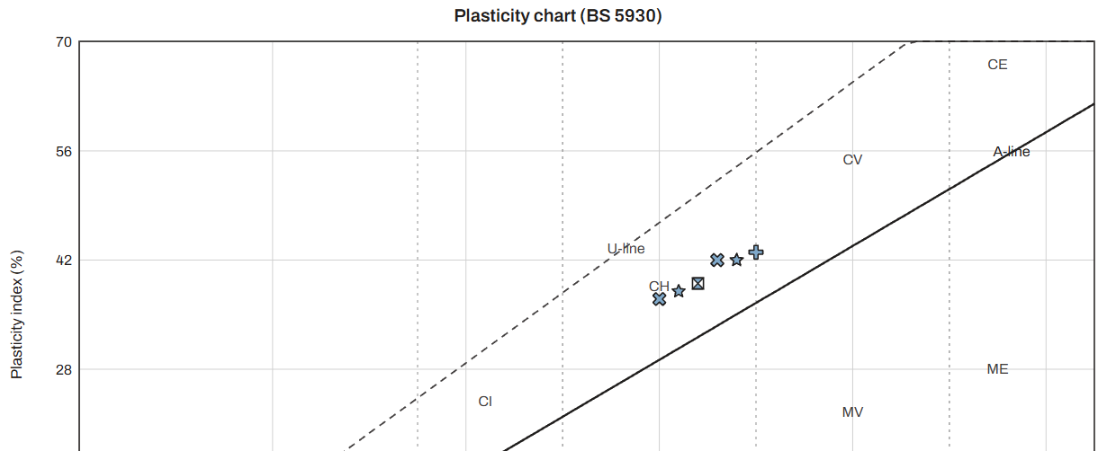
Plasticity chart and test results against depth, with an Excel workbook alongside. The lab schedule shows what was scheduled against what came back, sample by sample.
A factual report to the AGS Guide
Thirteen numbered sections and lettered appendices, built in Word from the data. Fields the tool cannot know print as a marker to complete before issue, never as plausible prose.
A desk study that runs itself
Once holes are located, the published geology and borehole records around the site are fetched from the British Geological Survey, or the Geological Survey of Northern Ireland, with their attribution, and filed with the job.
How it works
Three steps, from the rig's files to the client's copy.
Each job keeps its own record: its holes, schedules, lab results and issued documents stay together and apart from every other job.
01
Import
Drop in AGS files, borehole logs, the Schedule 2 and the laboratory results. A file can arrive on any screen.
02
Check
Read the register's counts and flags and the AGS conformance report. Every proposed repair is shown before it lands, and a derived value never looks like one the contractor supplied.
03
Issue
Generate the factual report, then issue it at a revision, P01, P02 and on. Nothing issued is ever overwritten: the client may be holding it.
Contractor and client
One job, two sides of the same data.
The contractor works the job. The client reads what has been shared with them, on the same drawings.
The contractor
The ground investigation team
Data intake, register, plan, logs and sections
Graphs and the lab testing schedule
The factual report and the issue register
Share a job with one named client
The client
The designer or consultant
Progress against the Schedule 2
The same site plan, with their own sections
The strata as logged, on each hole's log and the sections
The lab testing schedule: what was scheduled against what came back
The issued documents, at their revisions
Only the jobs shared with them, and nothing commercial
FAQ
Questions engineers ask first.
Which AGS versions does it read?
AGS 4, and AGS 3 and 3.1 files from older archives. Each file is checked for conformance, and the result is one click from the register.
Are the outputs design values?
No. Every output is a first-pass suggestion for a competent engineer to verify. Values read exactly from the AGS file, values the tool derived, and faults are told apart by colour and in words, such as the Exact and Interpreted tags on the intake bays and the reason printed beside each fault, so the three cannot be mistaken.
What if I only have the logs as PDFs?
StrataScope reads them: PDF, scan or photo. The read lands on the register for you to check against the logs, and later reads add to the job rather than replacing it.
What does the client see?
Only a job the contractor has shared with them by name, and only what has been issued and published to them. Nothing priced ever reaches a client screen. A document issued to the client is the contractor's: checked and issued by them, at its revision.
Where is my data stored?
StrataScope is not yet hosted for customers: it is in testing. Before any account opens, this answer will name the hosting provider and the region where each job's files and records are kept. Once it is, a log, lab sheet or core photograph you ask StrataScope to read is sent, from the server, to Anthropic's model to be read; Anthropic does not train on it. The privacy notice, how we use AI and the sub-processor list say who receives what.
What is coming next?
A section for designers to bring their own drawings (DXF and shapefiles) under the holes, and access-track design, are in development.
Terms used here
AGS file
Ground investigation data in the AGS Data Format, the industry's exchange format. StrataScope reads AGS 4, and AGS 3 and 3.1, and writes AGS 4.
Conformance check
A check of an AGS file against the format's rules, using the same open library as the British Geological Survey's validator. The report lists each rule a file breaks.
Schedule 2
The planned exploratory holes, before the works: their positions and target depths. It has no prices.
Register
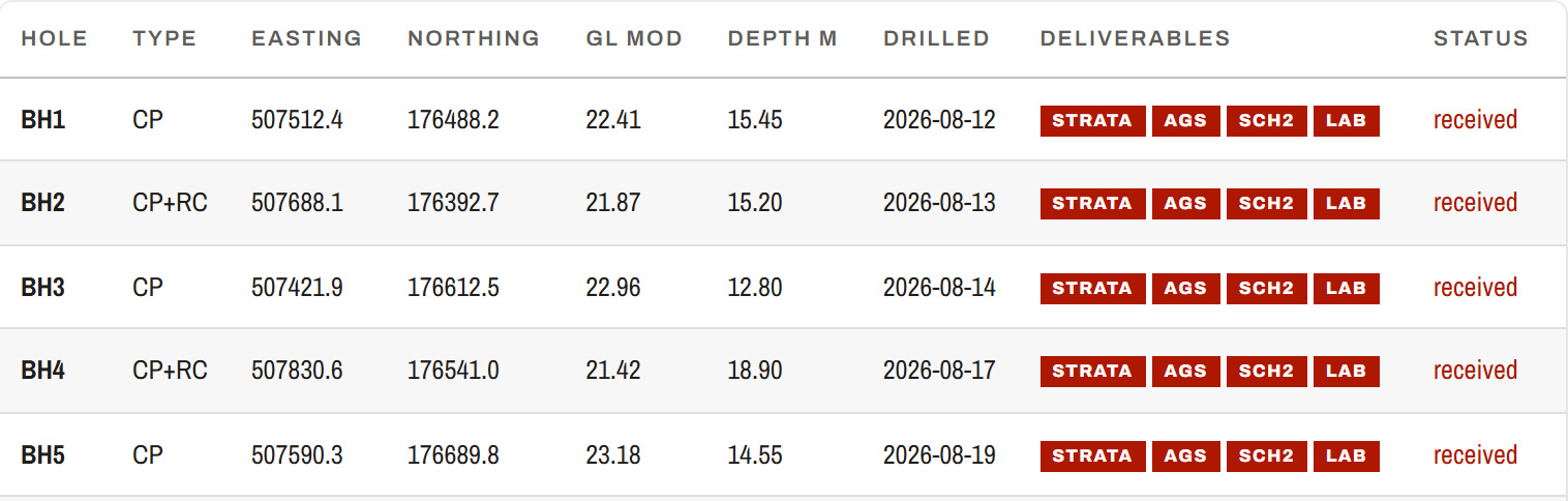
The list of holes on a job and what has come back for each: strata, AGS, Schedule 2 and laboratory results.
Factual report
The report of what was found, set out to the AGS Guide to Ground Investigation Reports: the holes, the ground as logged, the tests and the groundwater. It holds no ground model and no design parameters.
Fence
A section drawn between holes on the site plan, showing the strata of each hole side by side.
SPT N
The standard penetration test result: the blows to drive the sampler the last 300 mm, after two seating drives that are not counted.
cu
Undrained shear strength, in kPa, as tested.
RQD
Rock quality designation: the percentage of a core run made up of pieces 100 mm long or more.
mOD
Metres above Ordnance Datum, the level a hole's ground level is given in.
BGS ornaments
The British Geological Survey's lithology patterns, drawn as supplied under the Open Government Licence, so each soil and rock type is hatched the way geologists expect.
First pass
What every output is: a suggestion for a competent engineer to verify, never a design value.
See it worked through.
Ask for a walkthrough and we'll take you through StrataScope on our demo contract: an invented job built to read like a real one, so no project's data needs to leave your office.